
 For most of Florida, Hurricane Irma was a Category 1 storm or a strong Tropical Storm. But yet it has created the type of havoc around the state that no minor Hurricane should. For the Keys and southwest Florida, the storm was a monster and justifiably did a number on the area. But for areas like southeast Florida, central Florida and northwest Florida the infrastructure was tested and failed despite far from the worst case scenario taking place. Power began to go out for residents in Orlando and Jacksonville as the outer bands hit the area, long before the brunt of the storm created flooding concerns and wind damage. For those in southeast Florida, some lost power (including my residence) about seven hours before the worst of Irma arrived, though in fairness the portion of Broward County where I live had a sustained pounding for about 24 hours of mostly Tropical Storm force winds (with occasional Hurricane gusts). For our area Hurricane force winds did not arrive until LONG after the power was already out. As of now our power has not been restored but some areas in our neighborhood got power back this morning.
The larger power companies that service the state, Florida Power & Light, Duke Energy, TECO, etc all have failed to invest in the type of infrastructure that can withstand tropical storm winds or even in some cases intense thunder storms. Perhaps this is a legacy of a Public Service Commission (PSC) and Attorney General that doesn’t really regulate the power companies but serve as enablers for them instead.
Many are blaming the forecasters and National Hurricane Center (NHC) for not having the forecast track right. However, their was NEVER any doubt whatsoever that Irma was going to cause significant severe weather throughout the state and everyone associated with NHC and other accomplished meteorologists made that clear all along . But unfortunately many in our state aren’t adequately informed about tropical weather and projections something I find hard to believe living in Florida (though I must admit I am excessively;y geeky about Hurricanes and the history of storms in this state is one of my obsessions). Throughout the week leading into Irma, I fielded countless questions on Twitter and via text message about the projected track and about “leaving town”. Again as I mentioned yesterday Florida is a peninsula and a storm coming from south to north as the 1945 Homestead storm did, Charley did, Betsy did and to a lesser extent David and Matthew did tend to affect more than just a localized part of the state. Fleeing one part of the state to another during a storm taking a projected track like this makes little sense unless you are in a low-lying evacuation zone.
Also remember, the NHC projected track is just for the center of the storm and the 3 day cone represents the margin of error in that period for JUST THE CENTER OF THE STORM. No doubt modeling needs to improve and perhaps the NHC can show a cone near landfall that includes the potential wind field. But the NHC did well as usual with Irma. Sure the center of the storm tracked about 30-35 miles east of where forecast but again the cone represents a possible margin of error (the storm traveled the eastern edge of the cone) and potential storm impacts are NOT represented by the cone. While the NHC can certainly improve its communications and be more robust with its delivery of information, Floridians also need to take the time to understand what exactly the cone and map graphics mean.
The NHC issued Hurricane Warnings for the first time in history for the entirety of the peninsula of Florida. That should have been enough to make people realize how serious weather impacts could be in their area.
We have a lot of cleanup, recovery, thinking and analysis in the wake of Irma to do. We’ll continue to have these conversations this week here at TFS and hopefully everyone is in recovery mode and will have their lives back to normal by the end of the month.


I arrived in Miami by car from the west coast on Saturday morning around 9:30am. There must have been a wicked, fierce squall line that had gone through the area that morning or late evening. There were small branches and leaf debris everywhere in my neighborhood on wet streets. I had never seen anything like that as a precursor to rain bands in a tropical storm or hurricane in my 38 years living in Florida. This weather event happened hours before Irma’s rain bands as shown on radar arrived. I was up at 5am that morning watching Irma’s approach on radar. I monitored the rain band progression that morning both before and during my trip. I had timed my trip to arrive in Miami BEFORE Irma’s tropical force winds. I believe it was the early Saturday morning severe weather, whatever it was, that caused some power outages before Irma’s winds arrived.
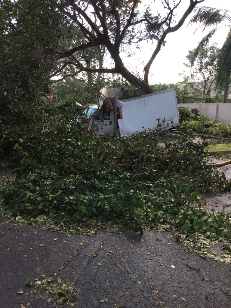
A large amount of Irma’s damage to power lines, fences, street lights, signs and landscapes was caused by the long duration tropical force winds – 8 or more hours. Present hurricane codes focus on top wind speeds, not duration.
The Saffir-Simpson scale served a great purpose, but it is past time for it to be replaced with a better indicator of potential storm damage that would not only include wind speeds, but also storm surge, rain, duration and areal coverage of winds. I noticed that north of the Keys, structural damage was limited mostly to fences, light and power poles, street signs and street lights. Houses were not destroyed and the majority of roofs survived with no damage unless a tree fell on a house. That is directly related to the duration of the lower magnitude winds. I think FPL and county governments should be asked to rethink their storm hardening planning ( or lack thereof ) that takes into account lower wind speeds for longer durations. Designing only to the highest magnitude wind is clearly not sufficient.
LikeLike