
Screenshot July 5, 2017 at 11:45 am ET. From NHC via Hurricane Tracker iOS app.
But down the road when a storm ravages the state and the forecast models weren’t as accurate as the media and politicians would have expected perhaps we can cite this moment when the pols were warned but didn’t do anything?
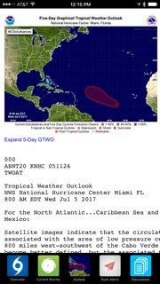
Meanwhile the tropics are active once again…
Having woken up from a decade-long run of luck (Florida suffered zero direct hits from Hurricanes from 2006 to 2015), Florida in 2017 seems as vulnerable as in 2004 and 2005. Already this summer, a tropical system has dropped records amount of rain in parts of the state
Typically in June and July, storms form off the Yucatan Peninsula or Central America, much like they do in October and November. However, the current disturbance (pictured at the right) which has a 70% chance of become something stronger has the characteristics of a classic Cape Verde type storm in terms of its location and pattern of potential development. Cape Verde storms typically appears from mid August until early October.
For now it’s important Floridians keep an eye on the tropics and prepare to cope with a potential storm this season. This potential storm may not threaten Florida but it’s ominous to see a Cape Verde type development in early July.


Thank you for your column today Kartik Krishnaiyer. I recently did a podcast interview with Steve Weagle, Chief Meteorologist at WPTV TV5 in West Palm Beach. We discuss NOAA cuts, and the deletion of work on predicting tornadoes in the Southern U.S, among other things, that will affect his ability to forecast locally in South Florida. Here is a link to the podcast interview. FYI: The first half of the interview is about Steve Weagle. The second half is regarding the budget cuts etc.
https://www.wpbcityvoice.com/wptv-5-weatherman-steve-weagle-talks-about-weagle-and-then-weather-city-voice-podcast-018/
LikeLike
Excellent! Thanks!!! This interview is great.
LikeLike